It was February of 2021. I'd just returned to Indiana University's Bloomington campus for the first time since the start of the pandemic. Sitting on my desk in the middle of the dimly lit and empty cubicle farm was a small folder. Trying to ignore the gloomy and cave-like atmosphere, I opened the folder and turned my attention to a curious set of sixteen hand-drawn map sheets, all sketched between 1926 and 1931 by someone who went by "Malott" or "C.A.M." It was an odd assortment of topographic and cave maps that paid meticulous attention to rises, sinks, swallow-holes, and a mysterious inland gulf. The maps were clearly related to Indiana karst topography, but what tied them all together and who was "Malott?"
A search on "Malott" in the BTAA Geoportal resulted in one other map, specifically Drainage Map of the Upper and Middle Parts of Lost River Basin: Orange, Washington, and Lawrence Counties, Indiana (Clyde A. Malott, Department of Geology, Indiana University, 1927).
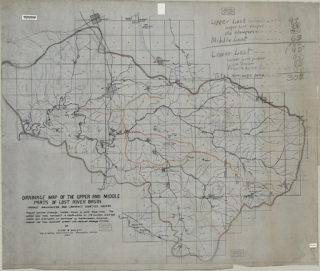
Clyde A. Malott's 1927 Drainage Map of the Upper and Middle Parts of Lost River Basin
This map proved to be my key to learning more about Malott and his mysterious maps. Born in Atlanta, Indiana, on 10 September 1887, Malott earned his Ph.D. from Indiana University in 1919. He began his career in geology as a tutor at IU in 1915 and progressed rapidly through the ranks to full professor in IU's Department of Geology and Geography by 1924. He is best remembered as the foremost authority on Indiana caves and underground streams. What I had on my desk were some of his earliest sketches of the karst topography and caves associated with Indiana's Lost River Basin.
Indiana's Lost River Basin
The Lost River is a tributary of the White River, joining its East Fork in the aptly named Lost River Township. It's unclear when European explorers first learned about the Lost River, but it appears on maps of the area as early as 1817 (See Shelton & Kensett's 1817 Map of The State of Indiana, available through the David Rumsey Map Collection). The Lost River is over 87 miles long with at least 23 of those miles run underground. Despite numerous attempts to map its course by exploring caves and tracing dye deposits through southern Indiana's many sinks and rises, much of the river's subterranean journey remains uncharted.
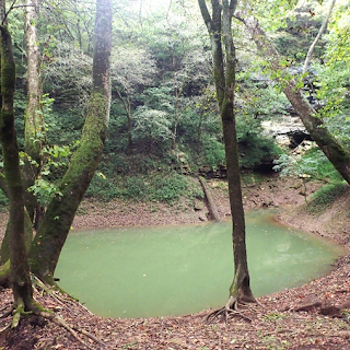
Among the Lost River Basin's more unique features is the Wesley Chapel Gulf located in the Hoosier State Forest. Although added to the list of National Natural Landmarks in 1972, the gulf appears to have been first mapped by Malott in 1921. Karst gulfs are formed when a cavern ceiling collapses, and in this one you can glimpse water from the Lost River where it surfaces at Boiling Springs Rise. During dry weather, the Hoosier Natural Forest webpage describes the spring site as a pool "25-30 feet deep, azure blue in color and perfectly calm. The water flows for a short distance, then disappears through the mud-covered talus rock at the base of the south wall of the gulf." During heavy rains, the gulf becomes a completely different beast—"At such times the waters issuing from the pit are violently turbulent and great boils of rising waters discharge from it. As much as 4,000—5,000 cubic feet per second issue from the underground course of Lost River." Not surprisingly, the Lost River Basin is prone to rapid flooding, and understanding the course of the Lost River is key both to understanding flood behavior and the area's ground water.
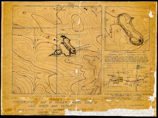
Clyde A. Malott's 1921 Topographic Map of Wesley Chapel Gulf of Lost River and Vicinity
Tragedy at Show Farm Cave

More digging revealed that the cave had a grim reputation, and one that further demonstrated the Lost River's volatile nature. On July 16, 1961, Tom Arnold and Ralph Moreland stopped to explore Show Farm Cave. Two more cavers waited for them at the entrance. Arnold and Moreland, who were both experienced cavers and students at IU, only planned to spend thirty minutes in the cave—just enough time to gather information for a guidebook to be given out at an upcoming caving convention.
A news story would later describe Show Farm as a "'storm sewer' type cave." During Malott's 1929 mapping expedition, he encountered pools of water starting 650 feet from the entrance and then standing water from 1500 feet on. At 2,485 feet, the water was only 1.5 feet below the ceiling.
Unfortunately, while Arnold and Moreland were exploring Show Farm Cave, a series of torrential downpours hit the area, dumping over five inches of rain between 5:00 and 7:30 pm. Within minutes, the water inside Show Farm was already so high and rapid that the cavers at the entrance were unable to reach Arnold and Moreland. Water continued to surge into the cave, and soon the entrance was under fifteen feet of water. When rescuers were finally able to enter early the next morning, they were greeted by "a crawl hole barely large enough for one man and suction from swollen waters of the Lost River" a mere 1,200 feet inside the cave.
Sadly, Arnold and Moreland were found drowned at a Y-intersection 3,000 feet from the cave's entrance—more than 500 feet past the farthest reaches of Malott's map. In response, the farmer who owned the land "vowed to seal the cavern forever," and the Indiana caving community seems to have gone to great lengths to literally wipe Show Farm's existence off the map.
Knowing the story of Show Farm Cave raises some interesting ethical questions from the perspective of description and access. Providing greater access to Malott's map also increases the possibility that inexperienced cavers, or even experienced cavers unfamiliar with the 1961 incident, might be tempted to place themselves in harm's way or to trespass on privately owned lands. Should all a cave, map like the one for Show Farm, be openly shared on publicly accessible websites? Should they be georeferenced? Should we add disclaimers and warnings?
On the other hand, papers reporting on the 1961 incident noted that only the first 600 feet of the cave were mapped. Malott's 1929 map, which shows the first 2,485 feet, must have been unknown to Arnold and Moreland. If they had known the watery conditions that awaited them, would they still have risked a spelunking expedition with a potential thunderstorm brewing?
Ultimately, I decided on cataloging and sharing the map with imprecise georeferencing. Fortunately, the rest of Malott's hand-sketched maps, such as the one of Wesley Chapel Gulf, proved to be of the Lost River's (generally) more serene features.
Ronda L. Sewald, Cartographic Resources Cataloger, Indiana University, Bloomington
References
Anon. 1927. "Professor Clyde Arnett Malott and Robert R. Shrock with the IU beginning geology class on spring field trip to Madison, May 8-9, 1927. Picture taken in front of one of the buses during stop in Nashville, Ind. Malott had his usual cigar in his mouth." https://earth.indiana.edu/giving/funds/cummings-malott-fund.html
Anon. 1961. "I.U. Students Found Dead in Cave," Daily Herald-Telephone. Vol. 85 (no. 57, July 19, 1961): Page 1+.
Anon. 1961. "Little Hope for Lost I.U. Students," Daily Herald-Telephone. Vol. 85 (no. 55, July 17, 1961): Page 1+.
Anon. 1961. "Search Continues for I.U. Students," Daily Herald-Telephone. Vol. 85 (no. 56, July 18, 1961): Page 1+.
Anon. 1961. "Two Explorers Are Found Dead in Cave," Decatur Daily Democrat. Vol. 59 (no. 168, July 19): Page 1.
Kensett, T. and W. Shelton. 1817. "Shelton & Kensett's Map of The State of Indiana. Place of publication not identified: Shelton & Kensett. Available through David Rumsey Map Collection: https://www.davidrumsey.com/luna/servlet/s/ldh6tq.
Shrock, Robert. 1985. "Biography: Clyde Arnett Malott." On Indiana University, Department of Earth and Atmospheric Sciences' "Cumings—Malott Memorial Fund" webpage: https://earth.indiana.edu/giving/funds/cummings-malott-fund.html.
https://www.fs.usda.gov/detail/hoosier/about-forest/?cid=fsbdev3_017567.