By Tara Anthony
The BTAA Geoportal provides opportunities for users to discover individual maps and geospatial items, along with collections of items within websites, online portals, and ArcGIS Hub Sites. One of these collections focuses on government open data portals that span multiple geographic locations of BTAA institutions. This post will highlight a selection of the content found in the BTAA Government Open Geospatial Data Collection.
What is in this collection?
Breadth of BTAA Government Open Data Collection
Viewing all items within the BTAA Government Open Data Collection provides you with over 14,000 records of content covering Pennsylvania, Maryland, Ohio, Indiana, Illinois, Iowa, Michigan, Minnesota, Nebraska, New Jersey, and Wisconsin. This includes resources classes of datasets, web services, imagery, websites, and maps. The website resources at the county and state levels provide discovery of geospatial data layers and content to the user. These results include content classified as vector data, polygon data, LiDAR, raster data, point data, line data, satellite imagery, and cadastral maps, with records primarily focused in the years from the mid-1900s to present with some earlier records. For instance, some of the earliest records within this collection, includes General Land Office (GLO) plats of Iowa from 1836 to 1859, and historic canal routes in Indiana during the 1830 to 1870 timeframe. More recent content is from many state and local government organizations, such as PASDA: The Pennsylvania Geospatial Data Clearinghouse, Maryland iMap, Open Data DC, Minnesota Geospatial Commons, GEOhio Spatial Data Discovery Portal, IowaDOT Open Data, New Jersey Geographic Information Network (NJGIN) Open Data Portal, City of Baltimore GIS Open Data, State of Michigan Open Data Portal, IndianaMap, Open Data PHLmaps, and Prince George's County GIS Open Data and many others as well.
What BTAA library submitted items to this collection?
Pennsylvania, Maryland, Ohio, Indiana, Illinois, Iowa, Michigan, Minnesota, Nebraska, New Jersey, and Wisconsin.
Focus on the Pennsylvania content
When viewing results, it is helpful to consider geographic area of interest and narrow additional facets on the side of the Geoportal interface accordingly. The search for Pennsylvania within the BTAA Government Open Geospatial Data Collection, includes almost 2500 items with content from PASDA: The Pennsylvania Geospatial Clearinghouse, Open Data PHL maps, Delaware Valley Regional Planning Commission (DVRPC), Centre County Open Data, Montgomery County Open Data, Alleghany County GIS Open Data, Crawford County Open Data, York County PA GIS Open data Portal, Western Pennsylvania Regional Data Center Open Data, Dauphin County GIS Data Portal, and Chester County GIS Data.
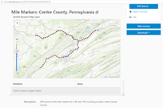
Example of a Mile Markers: Centre County, Pennsylvania - Big Ten Academic Alliance Geoportal (btaa.org) dataset and web service located in Centre County from Centre County Open Data
What to learn more? Where can I find out more?
Representatives of the BTAA institutions associated with the state or local government sources are helpful resources for learning more about government open data sources related to respective states. Reaching out to respective data providers are points of contact to learn more about these resources.