By Ronda L. Sewald, Cartographic Resources Cataloger, Indiana
Lake Monroe Land Suitability Study Topographic Map, 1975
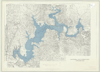
Topographic map of Lake Monroe accompanying the 1975 land suitability study. https://geo.btaa.org/catalog/e36066e5-5875-47fc-88c9-f751b8c89f69
Overview of Item
Lake Monroe was formed in 1965 by flooding the Salt Creek Valley located in southeastern Monroe County, Indiana. The Wabash River Basin, which covers most of Indiana and adjacent portions of Illinois and Ohio, was highly prone to flooding before this time. A 1933 report by the United States House Committee on Harbors and Rivers estimated the annual average cost of flood damage in the basin at $2,000,000 (roughly equivalent to $60,000,000 today) (page 9). The creation of Lake Monroe formed part of a basin-wide solution.

Comparison of topographic map from 1975 study with the United States Geological Survey’s 1947 7.5-minute series topographic map of “Allens Creek Quadrangle, Indiana (Monroe County).”
Although the lake helped with regional flooding issues, by the early 1970s, several local problems began to emerge. Lake Monroe had become a valuable water source for the growing Bloomington and Bedford communities. It also served as a major center of commerce due to its attractiveness as a tourist and recreation site, which in turn increased demand for building residential and commercial developments in the area. The popularity of the lake raised concerns that human activities would accelerate its eutrophication and that “the usual resultant problems of prolific weed and algal growth, deteriorating fisheries, impaired water quality, and sediment infilling” would pose serious threats to the lake (Gray, et al., page 10).
To better assess these issues, a land suitability study was designed “to provide a source of reliable information regarding the geology, ecology, land use, and institutional arrangements in the Lake Monroe Region”(Gray, et al., page i). The study involved over a dozen government organizations at the local, state, and federal level, as well as two corporations (Cook and Caslon Development), and was carried out by 21 Indiana University faculty members representing the Indiana Geological Survey, School of Public and Environmental Affairs, Department of Zoology, Department of Geography, and the School of Law.
The result of the study was a multidisciplinary 460-page report accompanied by four folded maps, including the one featured here showing the “intricate topography” of the Lake Monroe watershed with its “many interlacing ridges and ravines” (Gray, et al., page 27). Understanding the lake’s topography helps to answer questions regarding erosion, runoff, septic seepage, and building suitability.
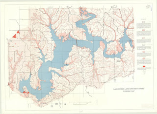
Geologic map of Lake Monroe accompanying the 1975 land suitability report. https://geo.btaa.org/catalog/09ac9d58-4243-4873-b1c9-fe3518d83401
Sources
Henry H. Gray, et al. July 1975. Lake Monroe Land Suitability Study: A Technical Report on a Selected Portion of the Lake Monroe Watershed. Indiana University, School of Public and Environmental Affairs, Center for Urban and Regional Analysis.
United States Geological Survey. 1947. “Allens Creek Quadrangle, Indiana (Monroe County).” 7.5-minute series topographic map. Available through the USGS topoView site at: https://ngmdb.usgs.gov/topoview/.
United States House Committee on Rivers and Harbors. 1933. Wabash River, Ohio, Indiana and Illinois. Letter from the Secretary of War transmitting pursuant to section 1 of the River and Harbor Act approved January 21, 1927.