By Daniel Dotson
Sometimes the changes are more complicated. For example, changes to the map interface may take a bit longer to implement. Adding options for help at the point of need (such as a clickable ? by certain features) would take more work.
So expect to see interface changes periodically as we work through these changes. But we depend on more than just user testing to make updates.
An easy example is language. Most content in the Geoportal is currently in English. How can you tell? Well you can’t. We don’t use language as either a searchable field or a filter option. So only people with access to the “back end” of the Geoportal can tell. So adding that functionality is a desire for updates to the Geoportal.

This also leads to us wondering about content not currently in the Geoportal. Members of the Geoportal collectively have well over a million maps in their collections (with overlaps, of course) and those maps represent over 100 languages! Of course, the majority are in English and European languages, but you can also see thousands of maps in languages such as Japanese, Chinese, and Indonesian. But we also have very unique cases, with only one map in languages like Basa, Inuktitut, and Kurdish. If we scan these print maps and add them to the Geoportal, that means changes to the interface. And we also need to work on metadata as some Geoportal content (and some of the print maps) don’t currently have languages listed.
So this is just our first attempt at sharing some of what is in store for the Interface. If you have ideas or suggestions for our interface, or anything else Geoportal related, please give us Feedback!
The BTAA Geoportal has several committees working towards making the Geoportal happen and improving it. This first blog is going to focus on examples of the Interface Committee's recent work and how that has affected the Geoportal.
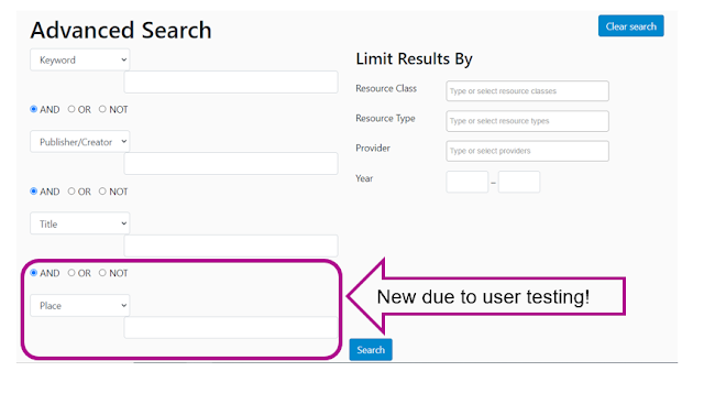
We take the information we gather from these tests and then decide on what changes we need to make to the interface to improve it. A simple change was to add a 4th search box to the advanced search since there were only 4 search fields - a student pointed that out as something we could do!
User Testing
We work with students (some familiar with geospatial information topics, some not) and walk them through a series of tasks to see how they respond. Do they find something hard to do? Do they misunderstand something they so or do? Do they not see a path to get the answer? Do they run into an error?We take the information we gather from these tests and then decide on what changes we need to make to the interface to improve it. A simple change was to add a 4th search box to the advanced search since there were only 4 search fields - a student pointed that out as something we could do!
Sometimes the changes are more complicated. For example, changes to the map interface may take a bit longer to implement. Adding options for help at the point of need (such as a clickable ? by certain features) would take more work.
So expect to see interface changes periodically as we work through these changes. But we depend on more than just user testing to make updates.
Diverse Collections
Do you know how to see how diverse the current BTAA Geoportal’s content is? It’s not easy, so this leads to some future options. Which means work with some of our other committees to make the diversity of our current Geoportal content easier to see. But also, examine possibilities for future content that would be more diverse.An easy example is language. Most content in the Geoportal is currently in English. How can you tell? Well you can’t. We don’t use language as either a searchable field or a filter option. So only people with access to the “back end” of the Geoportal can tell. So adding that functionality is a desire for updates to the Geoportal.
This also leads to us wondering about content not currently in the Geoportal. Members of the Geoportal collectively have well over a million maps in their collections (with overlaps, of course) and those maps represent over 100 languages! Of course, the majority are in English and European languages, but you can also see thousands of maps in languages such as Japanese, Chinese, and Indonesian. But we also have very unique cases, with only one map in languages like Basa, Inuktitut, and Kurdish. If we scan these print maps and add them to the Geoportal, that means changes to the interface. And we also need to work on metadata as some Geoportal content (and some of the print maps) don’t currently have languages listed.
Daniel Dotson serves as the Project's Interface Committee Co-chair. He is Head of Geology Library and Gardner Family Map Room, Mathematical Sciences Librarian & Science Education Specialist at The Ohio State University.