By Shirley Li
This interview is part of our Data Provider Series, which highlights local governments and institutions that offer open GIS data. In each interview, providers tell us about their missions and data resources. We hope this will be a great way for readers to learn more about local GIS developments and new initiatives.
Name: Gary Motz
Title: Assistant Director for Information Services
Division/Department: Indiana Geological & Water Survey
Website: https://igws.indiana.edu/
We are also a publisher and aggregator, so some of the data are created and maintained by other organizations that contribute to us. IndianaMap has been a platform for people that don't have extreme GIS skills or an ArcGIS Pro subscription to be able to see it.
The Information Services Division and the Research division of our organization work together to build databases, represent the data cartographically, and symbolize and document the data to produce the metadata.
Check out more data from IndianaMap in the BTAA Geoportal here.
Have questions about the BTAA geoportal, or maps and geospatial data in general? Please don’t hesitate to contact our project team!
Shirley Li is the GIS Analyst at Purdue University.
This interview is part of our Data Provider Series, which highlights local governments and institutions that offer open GIS data. In each interview, providers tell us about their missions and data resources. We hope this will be a great way for readers to learn more about local GIS developments and new initiatives.
Name: Gary Motz
Title: Assistant Director for Information Services
Division/Department: Indiana Geological & Water Survey
Website: https://igws.indiana.edu/
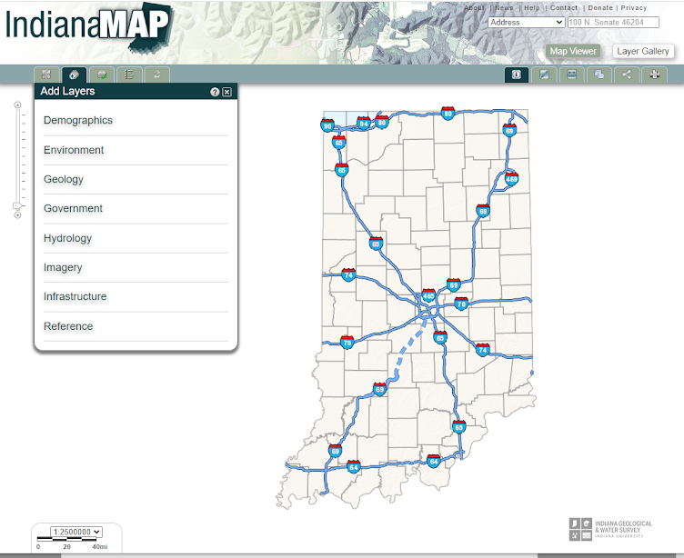
Screenshot of the IndianaMap Map Viewer. (https://maps.indiana.edu/)
What is the mission of your agency?
The mission of the Indiana Geological Water and Geological Survey (IGWS) is to provide geological information for the energy, mineral, and water resources of Indiana. Almost all of our natural resources are very geospatially focused. We maintain a number of data platforms for disseminating and sharing geospatially focused information.How long has your agency created and/or maintained geospatial data?
We’ve been around as a state agency since 1837, and we’ve been hosting the IndianaMap for at least 20 years now. Before that, we had many maps in paper form with an entire cartography/drafting section. We’ve been creating and maintaining geospatial data for many decades.What geospatial data layers do you create?
We create surveys of springs, caves, and natural hazards like earthquakes and faults among other features. This includes where you might expect to find various geological layers, what types of rocks that you would find underneath your feet in a spatial location or even in three dimensional geology if you were to stand at a point in the ground and then drill all the way through at that XY location, and how many different geological formations you would find at each depth (Z) as you're going down below the surface. Boreholes and well information is also extremely valuable information for us because oil and gas are not so much a major source of economic growth and potential for Indiana. A lot of those abandoned wells that were used back in the early 1900s for producing oil and gas are now being used for environmental reclamation for carbon sequestration, water, wastewater injection, or carbon dioxide injection. So a lot of the information that we produce is for reusing old data types for new applications because oil and gas is now carbon and it's just going in the opposite direction.We are also a publisher and aggregator, so some of the data are created and maintained by other organizations that contribute to us. IndianaMap has been a platform for people that don't have extreme GIS skills or an ArcGIS Pro subscription to be able to see it.
How do you create the geospatial data? (workflow, departments, processes)
Our cartographer, Matt Johnson, produces a lot of the visual appeal of the maps and helps with the knowledge, communication, and how the maps convey the types of information that our scientists are preparing and analyzing. Our researchers work on lots of different things by going out and collecting shallow passive seismic geophysical data. They look at subsurface reflectance of acoustic waves through the Earth to determine where the bedrock is and how much gravel from the glaciers got deposited on top of the state to see how much sand and gravel allows for that poor space for water to get in so we can learn more about water reservoirs and usefulness for utilities and public works. We build and maintain enormous geodatabases of our data and help to relate spatial data with more categorical data and empirical information from temperatures and the presence of water, and how water interacts with the rocks and the subsurface.The Information Services Division and the Research division of our organization work together to build databases, represent the data cartographically, and symbolize and document the data to produce the metadata.
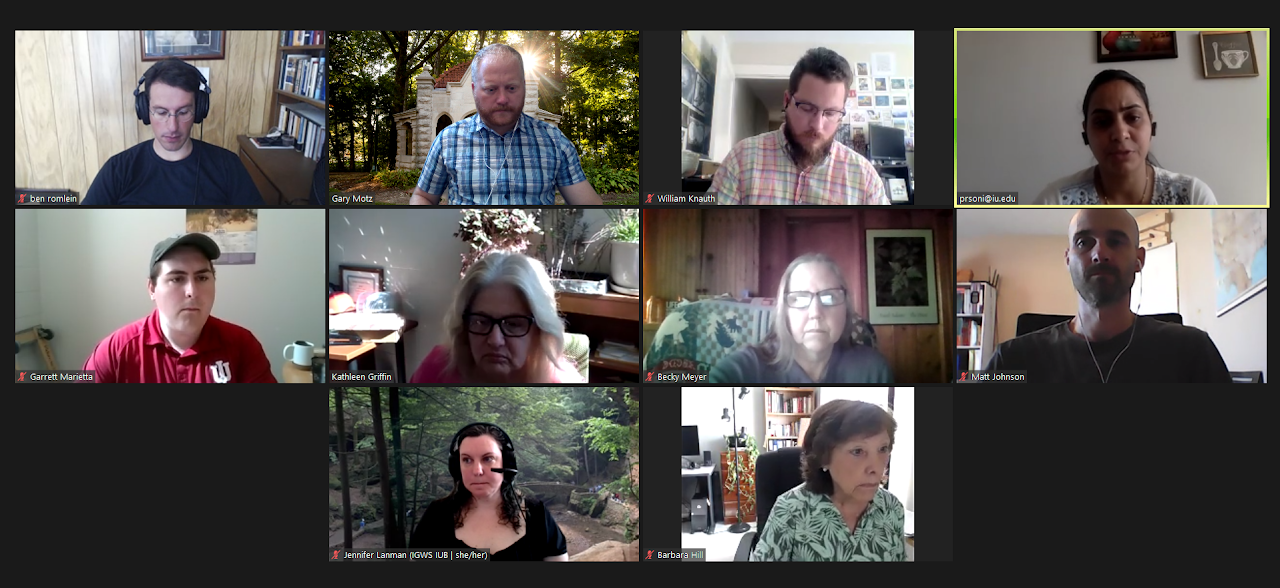
The Indiana Geological and Water Survey's Division of Information Services who serve as the maintainers of the IndianaMap. Pictured from top left to bottom right: Ben Romlein (GIS Developer), Gary Motz (Assistant Director for Information Services), Will Knauth (Digital Collections Manager), Pratima Soni (Web Developer), Garrett Marietta (Collections Technician), Kathy Griffin (Network/Systems Administrator), Becky Meyer (Database Administrator), Matt Johnson (Cartographer and Digital Projects Archivist), Jenna Lanman (Archivist and Collections Manager), Barb Hill (Photographer and Digitization Coordinator). Not pictured: Chris Dintaman (GIS Analyst and IndianaMap liaison).
What metadata format (documentation) does your agency use with geospatial data?
We use the Federal Geographic Data Committee’s Content Standard for Digital Geospatial Metadata (CSDGM: https://www.fgdc.gov/standards/projects/metadata/base-metadata/v2_0698.pdf), but we also use a number of other schemas including the U.S. Geological Survey’s Geologic Map Schema (GeMS: https://doi.org/10.3133/tm11B10). We try to stick to the published and maintained community-based standards for documentation of our geospatial data to make sure that they are broadly useful to not only our community but can be consumed by other geospatial data communities as well.How is your geospatial data distributed? / Who distributes your geospatial data?
We publish our geospatial data primarily using IndianaMap (https://maps.indiana.edu/), but we also use ArcGIS Online and the IGWS map (https://igws.indiana.edu/maps/categories/). We've got a number of different mapping applications depending on the theme or category of the data. If it is the statewide distribution of information, we'll put it on IndianaMap. If it's more research specialized for geological things, we'll put those on IGWS map, ArcGIS online maps, or story maps.Additional comments?
The important thing about geospatial data is that they are so pervasive and ubiquitous. These kinds of data are frequently useful in ways in which we cannot imagine right now. Over the years we're finding more people know about the IndianaMap including realtors, bank mortgage loan officers, and other communities. The commitment to documentation and metadata has helped us to make our data useful to other communities. This is not just a preservation of information for the integrity of the work to increase the trustworthiness of our data, but also it helps to increase the societal relevance and impact of our data for future generations. People are going to use data for new and exciting purposes in the future, and that really encourages me and gives me a lot of hope.Check out more data from IndianaMap in the BTAA Geoportal here.
Have questions about the BTAA geoportal, or maps and geospatial data in general? Please don’t hesitate to contact our project team!
Shirley Li is the GIS Analyst at Purdue University.