By Wenjie Wang
This interview is part of our Data Provider Series, which highlights local governments and institutions that offer open GIS data. In each interview, providers tell us about their missions and data resources. We hope this will be a great way for readers to learn more about local GIS developments and new initiatives.
Name: Mark Yacucci
Title: Head-Geoscience Information
Division/Department: Illinois State Geological Survey
Website: https://isgs.illinois.edu/
PRI comprises five state scientific surveys: the Illinois Natural History Survey, Illinois State Archaeological Survey, Illinois State Geological Survey, Illinois State Water Survey, and Illinois Sustainable Technology Center. Previously embedded within a state agency, these units were moved into the University of Illinois in 2008. Because of its unique mission to provide scientific expertise to state agencies, communities, industries, and individuals, with specific responsibilities described in state statutes, PRI is funded by a separate line-item in the state budget.
Check out more data from the Illinois Geospatial Data Clearinghouse in the BTAA Geoportal here.
Have questions about the BTAA geoportal, or maps and geospatial data in general? Please don’t hesitate to contact our project team!
Wenjie Wang is the Geographic Information Science (GIS) Specialist at the University of Illinois at Urbana-Champaign
This interview is part of our Data Provider Series, which highlights local governments and institutions that offer open GIS data. In each interview, providers tell us about their missions and data resources. We hope this will be a great way for readers to learn more about local GIS developments and new initiatives.
Name: Mark Yacucci
Title: Head-Geoscience Information
Division/Department: Illinois State Geological Survey
Website: https://isgs.illinois.edu/
Please briefly describe your role and what is the mission of your agency?
The Prairie Research Institute benefits the people, economy, and environment of Illinois, delivering impact to every corner of the state. Our staff apply scientific knowledge and data in geology, ecology and biodiversity, archaeology, water, weather and climate, pollution prevention, hazardous waste management, and sustainable energy.PRI comprises five state scientific surveys: the Illinois Natural History Survey, Illinois State Archaeological Survey, Illinois State Geological Survey, Illinois State Water Survey, and Illinois Sustainable Technology Center. Previously embedded within a state agency, these units were moved into the University of Illinois in 2008. Because of its unique mission to provide scientific expertise to state agencies, communities, industries, and individuals, with specific responsibilities described in state statutes, PRI is funded by a separate line-item in the state budget.
What is unique about ISGS offerings that others would be interested to know?
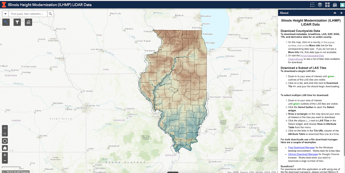
As we are a geological survey, we have many datasets in the domain of geology, but we have also have data and applications from other surveys in the Prairie Research Institute including the Illinois State Water Survey and Illinois Natural History Survey. The ISGS is also leads the Illinois Height Modernization Program with the Illinois Department of Transportation to contract collection of LiDAR elevation data which the ISGS then distributes via the clearinghouse.How is your geospatial data distributed? Who distributes your geospatial data?
Mostly online through traditional downloads of zipped data packages, but also through map and image services and applications. On occasion, we also fulfill larger requests via shipped hard drives. Applications range from data download for tiled data like LiDAR and aerial imagery, applications to help provide access to water and oil databases, applications that help illustrate where the state’s groundwater resources come from, as well as very popular applications for determining if a given location is undermined or what its township, range, and section.What is your most popular dataset?
Lidar is probably the most popular data on the clearinghouse in terms of downloads. But all of the aforementioned applications, while they may or may not generate downloads, it is also very popular and provide information that users cannot get elsewhere.Screenshot of the Illinois Height Modernization LiDAR Data interactive map.
Does your agency collaborate with other agencies? If so, can you provide some successful collaborations that lead to geospatial data creation?
In addition to our sister agencies and the University, We also collaborate with IDNR, IDOT, IEMA, and ISP on a variety of research and support activities. Much of this has been years in the making dating back to before the clearinghouse conception in the late 1990s. Ongoing communication and teamwork have been vital to this work.Future/what’s next/what datasets, projects are in the works you would like to share?
We are in the midst of transitioning our current Drupal website to an Open Data ArcGIS Hub site. This is tightly integrated with ArcGIS Online and will hopefully get all of PRI more involved in expanding our data offerings simply because of the ease of sharing through this platform. At the same time, we’re upgrading to the latest release of ArcGIS Enterprise software.Check out more data from the Illinois Geospatial Data Clearinghouse in the BTAA Geoportal here.
Have questions about the BTAA geoportal, or maps and geospatial data in general? Please don’t hesitate to contact our project team!
Wenjie Wang is the Geographic Information Science (GIS) Specialist at the University of Illinois at Urbana-Champaign