Featured Item: Shapefile of the 1968 Ecological Study for the Twin Cities Metropolitan Area: Composite Intrinsic Suitability
By Melinda Kernik
View Featured Item: Shapefile of the 1968 Ecological Study for the Twin Cities Metropolitan Area: Composite Intrinsic Suitability
A 6 x 6 foot, hand-drawn copy of McHarg’s Composite Intrinsic Suitability map is currently kept at the Borchert Map Library. Excitingly, it is now available as digitized vector data as well!
This new format makes it easier for researchers to examine land use change and the impacts of regional planning. When compared with data derived from 1968 land use maps or current parcels, it raises many possible questions:
Have questions about this item, the BTAA geoportal, or maps and geospatial data in general? Please don’t hesitate to contact our project team!
Melinda Kernik is the Spatial Data Analyst and Curator at the University of Minnesota.
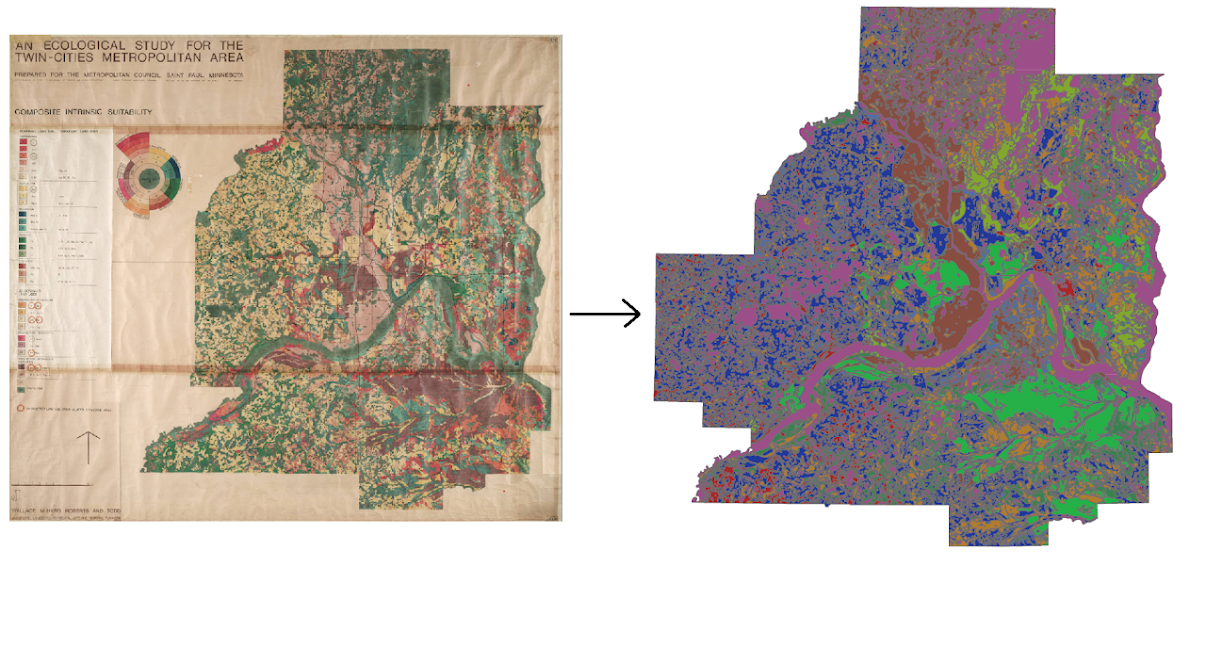
A scan of the 6 x 6 foot hand-drawn Composite Intrinsic Suitability map and derived GIS data.
View Featured Item: Shapefile of the 1968 Ecological Study for the Twin Cities Metropolitan Area: Composite Intrinsic Suitability
What is the item?
In 1968, Ian McHarg created a series of maps showing the climate, geology, and environment of the Twin Cities in Minnesota. These maps were commissioned by the Metropolitan Council, a first-of-its-kind regional governing body concerned about the impact of poorly managed urban development on natural spaces. The maps and report sought to determine the most suitable land uses for the region using an "ecology-first" lens.A 6 x 6 foot, hand-drawn copy of McHarg’s Composite Intrinsic Suitability map is currently kept at the Borchert Map Library. Excitingly, it is now available as digitized vector data as well!
This new format makes it easier for researchers to examine land use change and the impacts of regional planning. When compared with data derived from 1968 land use maps or current parcels, it raises many possible questions:
- How closely did planners and developers follow the 1968 recommendations?
- Are there patterns to where recommendations were followed and where they were not?
- How do McHarg’s recommendations compare to more recent plans proposed for the region?
What BTAA Library submitted the item?
University of MinnesotaInteresting tidbits:
- Graduate and undergraduate students spent over 200 hours digitizing the map!
- This data is the 500th item added to the Data Repository for the University of Minnesota (DRUM).
Where can I find out more?
- Scan of the original map
- Collection of maps associated with “An ecological study of the Twin Cities metropolitan area: Final report” (Wallace et al. 1969)
Have questions about this item, the BTAA geoportal, or maps and geospatial data in general? Please don’t hesitate to contact our project team!
Melinda Kernik is the Spatial Data Analyst and Curator at the University of Minnesota.