By Milan Budhathoki
This interview is part of our Data Provider Series, which highlights local governments and institutions that offer open GIS data. In each interview, providers tell us about their missions and data resources. We hope this will be a great way for readers to learn more about local GIS developments and new initiatives.

This interview is part of our Data Provider Series, which highlights local governments and institutions that offer open GIS data. In each interview, providers tell us about their missions and data resources. We hope this will be a great way for readers to learn more about local GIS developments and new initiatives.
Name: Julia Fischer
Title: Director, Data Services and the Maryland Geographic Information Officer (GIO)
Division/Department: Maryland Department of Information Technology (DoIT)
Website: https://imap.maryland.gov
DoIT’s mission is to provide vital technology solutions that allow the Executive Branch, State Agencies and Coordinating Offices to provide Marylanders with services that enable them to live and work more safely, efficiently and productively. In addition, the Data Services program seeks to improve the quality and lower the cost of government services, through collective investment in and effective application of data and systems and to reach beyond government by making data freely and publicly available to the fullest extent possible in consideration of privacy and security.
Access to open data, data that is freely and publicly available to the fullest extent possible in consideration of privacy and security, is accessible from Maryland’s Open Data Portal at https://opendata.maryland.gov and Maryland GIS Data Catalog at https://data.imap.maryland.gov. From these sites, visitors can search, explore, visualize, analyze, connect to and download more than 1,500 datasets from more than 60 contributing organizations, including local government partners. To provide further context, enhanced story features, which combine narrative content, data visualizations and media inputs convey how data and evidence-based information is supporting initiatives to better the work and lives of the constituents, businesses and visitors of Maryland.
As part of the responsibilities of data management is the review of submission adhering to the established enterprise data management standards. To support the application of these standards, we developed open data inspection analysis performed using automated scripts. The analysis is performed on a granular level, inspecting each record in the dataset, as well as an analysis to ensure a valid data schema. The analysis looks for data quality, data quantity, data duplication, as well as changes to the data. Information such as blank or null values, inconsistent cell characters, and count of changed records are made available to assess overall quality value of the data. This analysis occurs on a monthly basis and runs on all datasets hosted on Maryland’s open data portals.
Thanks to funding from the Maryland 911 Board and support from local government partners, more than 7 terabytes of current and archival versions of this data will continue to be made available as open data to search, explore, connect and download.
Another example is the on-going work related to the nationwide initiative to migrate and advance the 911 call systems to Next Generation 9-1-1 (NG9-1-1). Geospatial data provides the foundation upon which NG9-1-1 systems rely to improve response times and location accuracy each time a 911 Specialist answers the call. A significant aspect of NG9-1-1 is the expansive and expanding presence of mobile devices and data shared with mobile device vendors contributes to improvements in 911 call response times and caller location accuracy.
The state coordinated with the 24 primary Public Safety Answering Points (PSAPs), one within each local jurisdiction in Maryland, to prepare an authoritative, conterminous PSAP boundary layer. Available from Maryland’s Open Data Portal, the PSAP boundary layer has been provided to Apple and Google who are estimated to hold 99% of the nationwide market share of mobile devices. Through these partnerships, the boundary is correlated with the location data of the mobile device caller and securely connects the caller with the appropriate PSAP. On-going maintenance of the PSAP boundary layer and open communication with the vendors will ensure the reliability of this data for NG9-1-1 systems and will help save lives.
Portal visitors are able to access and visualize budget information, from the current as well as previous years, including expenditure and fund details, vendor payments, grant and loans, staffing counts, direct links to performance metrics and much more. Portal visitors can explore the site and quickly identify which programs received funding. The Maryland Transparency Portal provides valuable access to information to ensure the constituents and businesses of Maryland are informed on how tax dollars are being applied.
Check out more data from Cook Central in the BTAA Geoportal here.
Have questions about the BTAA geoportal, or maps and geospatial data in general? Please don’t hesitate to contact our project team!
Milan Budhathoki is the Geospatial Librarian at University of Maryland Libraries
Division/Department: Maryland Department of Information Technology (DoIT)
Website: https://imap.maryland.gov
Please briefly describe your role and what is the mission of your agency?
Julia: As the Maryland Geographic Information Officer (GIO) and the Director, Data Services within the Maryland Department of Information Technology (DoIT), I am responsible for leading, advancing and promoting the data services program. This program consists of three main technologies: Business Intelligence (BI), Geographic Information Systems (GIS) and Open Data (OD). We continue to expand the scope of the program to include data management, system interoperability and advanced analysis and conduct pilot projects using complementary technologies such as Artificial Intelligence (AI), Machine Learning (ML) and Natural Language Processing (NLP).DoIT’s mission is to provide vital technology solutions that allow the Executive Branch, State Agencies and Coordinating Offices to provide Marylanders with services that enable them to live and work more safely, efficiently and productively. In addition, the Data Services program seeks to improve the quality and lower the cost of government services, through collective investment in and effective application of data and systems and to reach beyond government by making data freely and publicly available to the fullest extent possible in consideration of privacy and security.
What is unique about your team/department offerings that others would be interested to know?
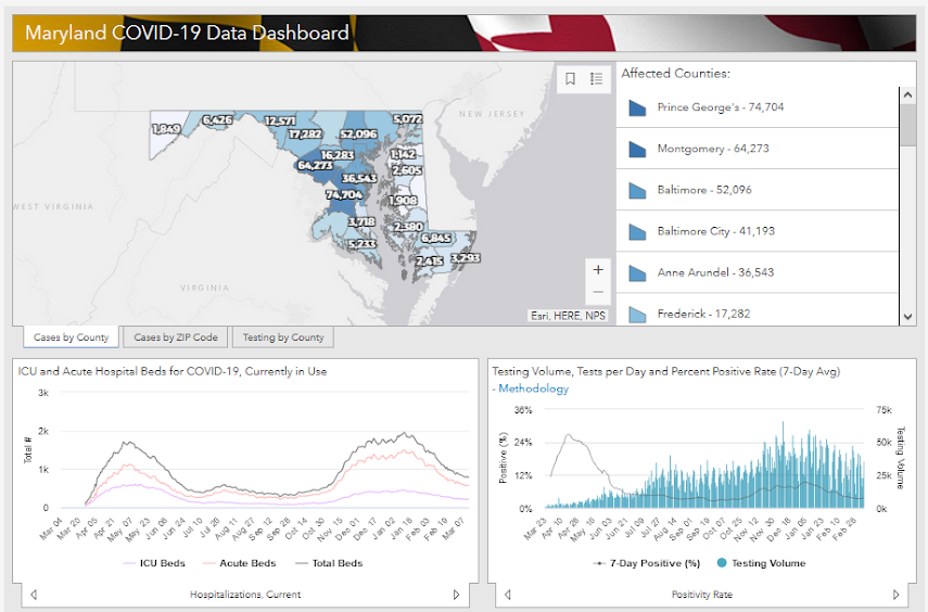
Julia: In March 2020, my team along with partners from the Maryland Department of Health (MDH), the Governor’s Office and the Maryland Emergency Management Agency (MEMA) collaborated to launch Maryland’s COVID-19 site at https://coronavirus.maryland.gov. The site is built on the state’s enterprise GIS and Open Data platforms. The original site was developed in just over 4 hours and has since grown to welcome more than 14,000,000 visitors. The site is the nerve center focused on the health and safety of Marylanders with access to map apps that direct citizens to COVID testing and vaccination sites, as well as reporting more than 50 vital statistics related to the pandemic. In addition, site visitors can search, explore, connect to and download the raw data from Maryland’s GIS Data Catalog at https://data.imap.maryland.gov and Maryland’s Open Data Portal at https://opendata.maryland.gov.Maryland COVID-19 Data Dashboard at https://coronavirus.maryland.gov
Why do you think it is important to make data publicly available? Can you describe how your geospatial data is distributed? How is the quality of the geospatial data controlled before making it public?
Julia: Data is the government’s most valuable asset. Throughout the COVID-19 pandemic, the State of Maryland has remained focused on providing reliable and accurate data available to the public. This focus has resulted in developing new and strengthening existing partnerships, empowering collaborative analysis and revealing correlations between previously, independently maintained data, affording the opportunity to have the best and brightest contribute answers and solutions and reaching beyond government to include members of the community who contribute valuable insights and new perspectives.Access to open data, data that is freely and publicly available to the fullest extent possible in consideration of privacy and security, is accessible from Maryland’s Open Data Portal at https://opendata.maryland.gov and Maryland GIS Data Catalog at https://data.imap.maryland.gov. From these sites, visitors can search, explore, visualize, analyze, connect to and download more than 1,500 datasets from more than 60 contributing organizations, including local government partners. To provide further context, enhanced story features, which combine narrative content, data visualizations and media inputs convey how data and evidence-based information is supporting initiatives to better the work and lives of the constituents, businesses and visitors of Maryland.
What challenges and opportunities do you see with geospatial data in your agency? Does your agency have a long term data management plan? If so can you briefly talk about data curation and preservation effort so far?
Julia: Several challenges were highlighted during the recent activities related to COVID support. One in particular had to do with ensuring the reliability and securing the public’s trust of the data being presented. My team is very passionate about providing reliable products and took opportunities to proactively seek feedback from Marylanders through social media and other forms of communication to ensure the best user experience. In addition, we have been in communication with leaders from the public and private sectors across the country asking questions and learning how to improve the site based on their expertise and experience.As part of the responsibilities of data management is the review of submission adhering to the established enterprise data management standards. To support the application of these standards, we developed open data inspection analysis performed using automated scripts. The analysis is performed on a granular level, inspecting each record in the dataset, as well as an analysis to ensure a valid data schema. The analysis looks for data quality, data quantity, data duplication, as well as changes to the data. Information such as blank or null values, inconsistent cell characters, and count of changed records are made available to assess overall quality value of the data. This analysis occurs on a monthly basis and runs on all datasets hosted on Maryland’s open data portals.
Does your agency collaborate with other agencies, institutions and regional/local governments within Maryland? If so can you provide some successful collaborations that lead to geospatial data creation?
Julia: Partnerships are an essential component of delivering valuable data to Marylanders. Local governments serve the citizens and businesses within their communities firsthand and as a result possess great insights and knowledge at a granular level. These partnerships continue to benefit from sharing data, resources and technology. This year kicked off the ninth year of Maryland’s digital high-resolution imagery program. Through this program aerial photography is captured for the entire state of Maryland. This data is a valuable framework dataset, critical in supporting emergency response dispatch, surveying, environmental conservation and planning. An abundance of other programs at the federal, state, local governments, private sector, non-governmental organizations, academic and research institutions and the general public benefit from the availability of this open data.Thanks to funding from the Maryland 911 Board and support from local government partners, more than 7 terabytes of current and archival versions of this data will continue to be made available as open data to search, explore, connect and download.
Another example is the on-going work related to the nationwide initiative to migrate and advance the 911 call systems to Next Generation 9-1-1 (NG9-1-1). Geospatial data provides the foundation upon which NG9-1-1 systems rely to improve response times and location accuracy each time a 911 Specialist answers the call. A significant aspect of NG9-1-1 is the expansive and expanding presence of mobile devices and data shared with mobile device vendors contributes to improvements in 911 call response times and caller location accuracy.
The state coordinated with the 24 primary Public Safety Answering Points (PSAPs), one within each local jurisdiction in Maryland, to prepare an authoritative, conterminous PSAP boundary layer. Available from Maryland’s Open Data Portal, the PSAP boundary layer has been provided to Apple and Google who are estimated to hold 99% of the nationwide market share of mobile devices. Through these partnerships, the boundary is correlated with the location data of the mobile device caller and securely connects the caller with the appropriate PSAP. On-going maintenance of the PSAP boundary layer and open communication with the vendors will ensure the reliability of this data for NG9-1-1 systems and will help save lives.
Do you have any additional interesting and impactful work(s) you like to share that are not covered so far?
Julia: The Maryland Department of Budget and Management (DBM) and the Maryland Department of Information Technology (DoIT) continues to collaborate to maintain transparency of the state’s budget and associated funding programs. The Maryland Transparency Portal located at https://mtp.maryland.gov is hosted on Maryland’s Open Data Portal, resulting in a streamlined approach to interacting with the site and the underlying data.Portal visitors are able to access and visualize budget information, from the current as well as previous years, including expenditure and fund details, vendor payments, grant and loans, staffing counts, direct links to performance metrics and much more. Portal visitors can explore the site and quickly identify which programs received funding. The Maryland Transparency Portal provides valuable access to information to ensure the constituents and businesses of Maryland are informed on how tax dollars are being applied.
Check out more data from Cook Central in the BTAA Geoportal here.
Have questions about the BTAA geoportal, or maps and geospatial data in general? Please don’t hesitate to contact our project team!
Milan Budhathoki is the Geospatial Librarian at University of Maryland Libraries