Geospatial Data Project - Tutorials
This month, the BTAA Geospatial Data Project is unveiling a series of tutorials to showcase the practicality of the BTAA Geoportal for teaching and learning about maps, geospatial data, and GIS techniques. These tutorials cover a wide range of activities designed to meet the needs of instructors and students in different fields and levels of competency in data retrieval, use, and analysis. The inaugural collection contains the following six tutorials as slides that can be incorporated into in-person, hybrid, or fully online instructional contexts:
We hope that these tutorials will help instructors plan labs and lectures and encourage instructors to incorporate these slides into their course content. We also encourage students and geoportal users to peruse this content for a better understanding of how to use the data in the BTAA Geoportal for assignments, projects, research, and GIS activities. If you are interested in taking a look, these tutorials can be found here.
This month, the BTAA Geospatial Data Project is unveiling a series of tutorials to showcase the practicality of the BTAA Geoportal for teaching and learning about maps, geospatial data, and GIS techniques. These tutorials cover a wide range of activities designed to meet the needs of instructors and students in different fields and levels of competency in data retrieval, use, and analysis. The inaugural collection contains the following six tutorials as slides that can be incorporated into in-person, hybrid, or fully online instructional contexts:
Find a Map Image for Simple Use
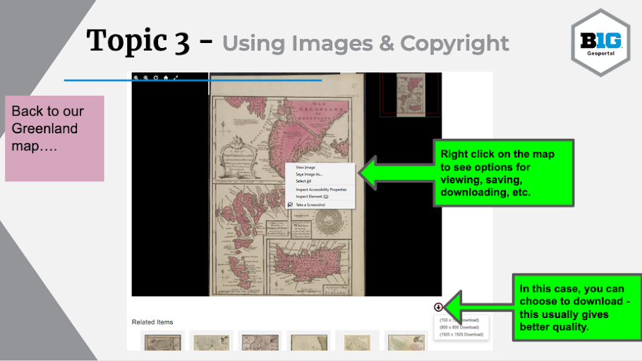
Find a Map Image for Simple Use, by Danny Dotson at Ohio State University, is designed to help students locate a map for a given topic and use it in a document. This tutorial reviews the steps required to locate a relevant map, using the BTAA Geoportal, how to download or copy the scanned map, how to insert the map into a given document, and provides an overview of basic fair use and copyright implications for using these maps.
Types of Geospatial Information
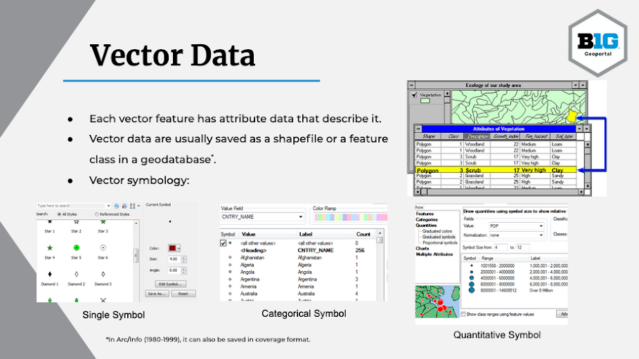
Types of Geospatial Information, by Nicole Kong at Purdue University, introduces students to the most commonly used types of data in GIS. Using a range of visual and diagrammatic examples, it reviews the different data models that GIS professionals typically use to collect and share information, and which are discoverable through geodata portals.
Finding Geospatial Data
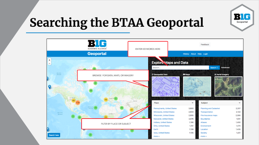
Finding Geospatial Data, by Joshua Sadvari at Ohio State University, is intended to help geoportal users frame a search strategy and perform a search for geospatial data. The tutorial is divided into two activities designed to teach students how to access relevant geospatial data using the BTAA Geoportal based on their research or assignment objectives.
Evaluating Geospatial Information
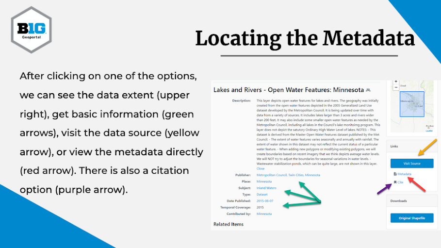
Evaluating Geospatial Information, by Ryan Mattke at the University of Minnesota, is designed to help students evaluate geospatial data on the BTAA Geoportal for research and coursework. This tutorial reviews how to determine if metadata exist for a resource, how to review this metadata to understand the data’s authority, quality, and relevance, and where to find citation information for resources found with the geoportal.
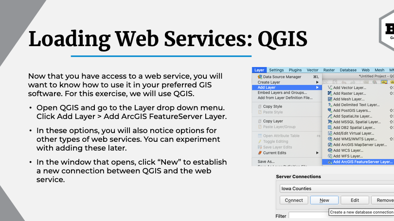
Using GIS Web Services
Using GIS Web Services, by Jay Bowen at the University of Iowa, is meant to give GIS users a basic understanding of GIS web services, how to find them using the BTAA Geoportal, and how to use them in QGIS, ArcGIS Desktop, ArcGIS Online, and ArcGIS Pro. The tutorial also contains a link to a walkthrough demonstrating how to use GIS web services to create an interactive web map with Leaflet.
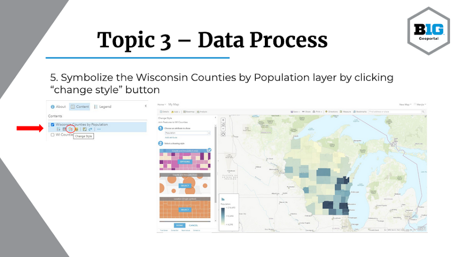
Linking Tabular Data to Geospatial Data
Linking Tabular Data to Geospatial Data, by Wenjie Wang at the University of Illinois at Urbana-Champaign, provides step-by-step instructions for downloading and visualizing spreadsheet data in ArcGIS Online by linking tabular data to geospatial data with a key index variable. More specifically, the tutorial gives an overview of how to locate and download a Wisconsin county boundaries shapefile and a data table of population for each county from the US Census Bureau. The tutorial then explains how to prepare the data, add these files to ArcGIS Online, and join the Census data to the county shapefile using the matching county names column in both files. Finally, the tutorial introduces how to symbolize the joined data using county population.
We hope that these tutorials will help instructors plan labs and lectures and encourage instructors to incorporate these slides into their course content. We also encourage students and geoportal users to peruse this content for a better understanding of how to use the data in the BTAA Geoportal for assignments, projects, research, and GIS activities. If you are interested in taking a look, these tutorials can be found here.