By Melinda Kernik and Laura McElfresh
This interview is part of our Data Provider Series, which highlights local governments and institutions that offer open GIS data. In each interview, providers tell us about their missions and data resources. We hope this will be a great way for readers to learn more about local GIS developments and new initiatives.
Name: Zeb Thomas
Title: GIS Data Systems Coordinator
Division/Department: MNIT Services Partnering with the MN Department of Natural Resources
Website: https://www.dnr.state.mn.us/
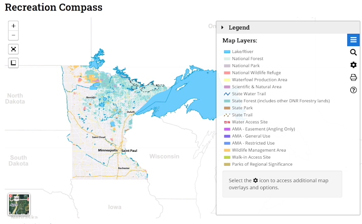
In addition to datasets, the DNR publishes geoPDF maps of parks, trails, and ATV paths to Avenza for use in recreation. We also have a lot of mobile apps for distributing data; for example, RecCompass.
The DNR also has a *lot* of land to keep track of. We maintain data about the land and minerals -- so we are a first stop for people needing that info.
In the last year, there has been a lot of interest in data connected to the Minnesota Hydrogeology Atlas, which contains information like water-table elevation and depth to the water table.
Another popular resource published in the past year has been 2019 NAIP (National Agriculture Imagery Program) satellite imagery. We sometimes download and republish data like this - information that was created by other agencies. We have to be careful because we don’t want to duplicate or cause confusion about data that will eventually be available somewhere else. But in this case, it’s an important-enough resource that it’s worth timely publishing and committing to taking care of the data.
GIS is central to the DNR’s mission!
Thank you, Mr. Thomas for the great interview!
Check out Minnesota Geospatial Commons datasets in the BTAA Geoportal here.
Have questions about the BTAA geoportal, or maps and geospatial data in general? Please don’t hesitate to contact our project team!
This interview is part of our Data Provider Series, which highlights local governments and institutions that offer open GIS data. In each interview, providers tell us about their missions and data resources. We hope this will be a great way for readers to learn more about local GIS developments and new initiatives.
Name: Zeb Thomas
Title: GIS Data Systems Coordinator
Division/Department: MNIT Services Partnering with the MN Department of Natural Resources
Website: https://www.dnr.state.mn.us/
1. What is the mission of your agency?
The DNR has three primary missions: 1) to conserve and manage natural resources; 2) to provide outdoor recreation opportunities; and 3) to support commercial uses of natural resources. These missions are sometimes in conflict, but all relate to promoting a high quality of sustainable life & good management of our environment…the better the data you have, the better you can conserve and manage resources.2. How is your geospatial data distributed?
Much of the data that the DNR produces is available on the Minnesota Geospatial Commons. This website provides a way for government agencies in Minnesota to share data internally with one another and externally with the public. We are the largest contributor to the Commons, which also has data from counties, the University of Minnesota, state agencies and other local governments.In addition to datasets, the DNR publishes geoPDF maps of parks, trails, and ATV paths to Avenza for use in recreation. We also have a lot of mobile apps for distributing data; for example, RecCompass.
Recreation Compass is an easy to use web application showing the locations of state and federal parks, forests, land and water trails, wildlife refuges and management areas, waterfowl production areas, scientific natural areas, water accesses, walk-in access sites.
3. What is unique about your data offerings that others would be interested to know?
We have a lot of direct-to-consumer apps. These are designed for the public, not necessarily for experts. So we need to make sure that they are usable by a broad audience -- there’s lots of subtle mobile cartography going on there! It’s important to make sure people can understand the data so they won’t end up accidentally trespassing!The DNR also has a *lot* of land to keep track of. We maintain data about the land and minerals -- so we are a first stop for people needing that info.
4. What is your most popular dataset?
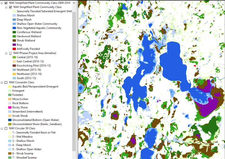
Historically, it has been hydrography datasets -- the National Wetland Inventory for Minnesota and the DNR Hydrography Dataset. Another popular dataset has been wildfire tracking (Wildfires Tracked by Minnesota DNR). Counties use this for tracking costs of damage and claims.In the last year, there has been a lot of interest in data connected to the Minnesota Hydrogeology Atlas, which contains information like water-table elevation and depth to the water table.
Another popular resource published in the past year has been 2019 NAIP (National Agriculture Imagery Program) satellite imagery. We sometimes download and republish data like this - information that was created by other agencies. We have to be careful because we don’t want to duplicate or cause confusion about data that will eventually be available somewhere else. But in this case, it’s an important-enough resource that it’s worth timely publishing and committing to taking care of the data.
A screenshot of the National Wetland Inventory for Minnesota
5. Do you have any datasets / projects that are in the works you would like to share?
We are working on extending our Minnesota Climate Trends application to include projections of future climate. Using a simple map interface, you can currently choose delineations of interest such as counties, watersheds, municipalities -- however you want to slice it. You can choose four counties, you can do statewide... Within these areas of interest you can see long-term climate trends from 1895 to the present day such as precipitation and temperatures. The new projections are being developed in partnership with the State Climatologist who works at University of Minnesota (in a hybrid arrangement). They are working together with DNR to produce climate predictions. The predictions look at mid-century (2040-2050) and late century (2080-2090) under two scenarios: a best case scenario and then a worst case scenario --like if we just gave up. It will be less of a month-to-month prediction of changes and more focused on broad trends. The mid-century data is already pretty scary -- for instance it predicts that there could be double digit temperature increases in winter. Hopefully the application will be available in the next few months or by the end of the year.6. Anything else you want folks to know?
The last few months have required a large transition to work-from-home and mobile work. Our staff provide a mix of applications and support - so we do a lot of work helping others access information and technology. Data has been loading slower for folks working-from-home. We have had to be creative trying to mitigate that and walking people through workarounds.GIS is central to the DNR’s mission!
Thank you, Mr. Thomas for the great interview!
Check out Minnesota Geospatial Commons datasets in the BTAA Geoportal here.
Have questions about the BTAA geoportal, or maps and geospatial data in general? Please don’t hesitate to contact our project team!