By Karen Majewicz
The
Minnesota Geospatial Commons was officially launched in 2015, and serves as the state’s central clearinghouse for public geospatial data. The site runs on an open source application (CKAN) and is operated by the
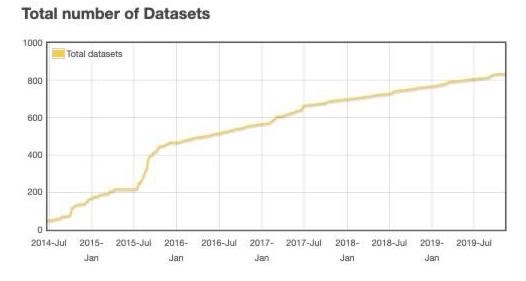
Minnesota Geospatial Information Office (MnGeo). The Commons has grown from about 200 unique datasets at the time of public launch to over 800 today.
Contributors
Contributors include state departments and agencies, such as Natural Resources, Transportation, Health, Agriculture, Revenue, Education, Water & Soil, and Animal Health. Metropolitan entities, such as the Emergency Services Board, the Mosquito Control District, and MetroGIS have also contributed resources. Submitting public data to the Commons is voluntary, but several counties, including Dakota, Itasca, Faribault, Hennepin, Lake, Meeker, Ramsey, St. Louis, Rice, Steele, and Waseca have taken advantage of the platform to deliver their resources to a broader audience. On the academic front, research data from the University of Minnesota Twin Cities and the Natural Resources Research Institute at the University of Minnesota Duluth has also been contributed.
Metadata
One of the most impressive aspects of the Commons is its consistent adoption of the
Minnesota Geographic Metadata Guidelines (MGMG). All resources in the Commons are reliably accompanied by high quality metadata, allowing users to understand when, where, why, who, and how the resource was created.
Most popular record in the Commons
The most popular geospatial dataset of 2018 (with 8571 page views!) was
School District Boundaries, Minnesota, SY2018-2019 , which represents the boundaries of all public school districts in the state of Minnesota.


